Tropical Depression Nine forms in the Gulf with a dangerous hurricane forecast near the northern Gulf Coast
Tropical Depression Nine formed in the Gulf on October 6 with 35 mph winds. The National Hurricane Center forecasts it to become a hurricane Thursday and approach the northern Gulf Coast as a dangerous hurricane Friday. No coastal watch or warning was in effect at Advisory 1.
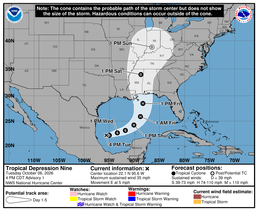
The National Hurricane Center began advisories on Tropical Depression Nine at 4 p.m. Central on Tuesday, with a forecast that takes the new Gulf cyclone to hurricane strength Thursday and brings it near the northern Gulf Coast as a dangerous hurricane Friday.
No coastal watch or warning was in effect with Advisory 1. The center said people along the U.S. northern Gulf Coast and in the Yucatan Peninsula should monitor the system, and that watches could be required for part of the northern Gulf Coast on Wednesday.
Where the storm is now
At 4 p.m. Central, the center was near latitude 22.1 north, longitude 95.6 west, with maximum sustained winds of 35 mph and a minimum central pressure of 1007 millibars. It was moving east at 5 mph.
The Hurricane Center forecasts an eastward to east-northeastward track for the next two days, followed by a turn toward the northeast Friday. On that track, the center should pass north of the Yucatan Peninsula Thursday and approach the U.S. northern Gulf Coast Friday.
The first forecast reaches hurricane strength Thursday
The numbered forecast reaches 80 mph by Thursday afternoon, 90 mph early Friday and 100 mph Friday afternoon. The discussion says conditions are conducive for strengthening and that the system is likely to grow significantly, especially east of the center.
Some weakening is possible as the cyclone nears the coast because wind shear is forecast to increase. The same discussion says the storm is still expected to be a dangerous hurricane at landfall.
There is meaningful uncertainty over where the northeast turn occurs and how quickly the storm moves after that turn. The cone spans much of the north-central and northeastern Gulf Coast by Friday, and it describes the probable path of the center rather than the reach of wind, rain or surge.
Heavy rain is possible from Louisiana to the Panhandle
From Friday through the weekend, the Hurricane Center forecasts 3 to 6 inches of rain with isolated totals as high as 10 inches from southeastern Louisiana to the Florida Panhandle. Flash flooding, urban flooding and isolated river flooding are possible.
Southwest Florida is outside the Advisory 1 cone and has no tropical watch or warning. That does not make the first forecast final. The useful local step is to keep checking the official products while the turn and the storm's eventual size come into better focus.